Exclusive Private Services: Excursions, Shore Trips, Daily Tours & Transfers Contact Us
24-Hour Service
Exclusive Private Services: Excursions, Shore Trips, Daily Tours & Transfers Contact Us

Call us anytime
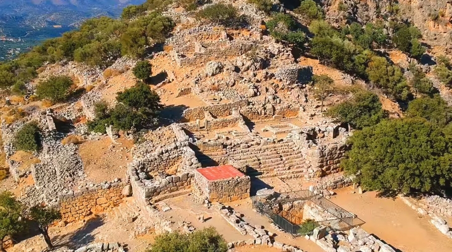
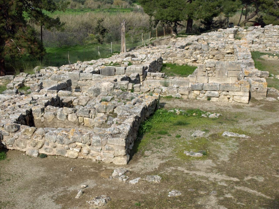
The urban center of the city-state of the Latians is built in a naturally-fortified location controlling the passage from central to eastern Crete. The city’s visible building remains, which are in such a good state that Lato is considered one of the best-preserved Classical-Hellenistic cities in Crete, belong to the 4th and 3rd c. BC; however, excavation brought to light terracotta figurines and plaques of the 7th and 6th c. BC, and pottery kilns for vases and figurines of the same period. In addition, Late Minoan IIIC pottery found in the area of the ancient city shows that habitation here goes back at least as far as the 12th c. BC. The city was surrounded by a strong wall with gates opened around it. The main and most impressive of these is the one in which a path leading from the entrance of the archaeological site runs through. Entering this gate, the main street leads up the hill to the city’s Agora. On the right side of the street there is a series of buildings identified by the excavators as shops and workshops. On the left there are seven terraces each corresponding to a residence. The Agora, an open area between the north and south acropolises and the east and west residential neighborhoods, has an irregular trapezoidal shape with a Doric stoa on its west and an open platform on its south. Its center is taken up by a small, probably open-air temple of uncertain date. North of the temple was a large underground reservoir, which, by virtue of its location in the residential center and its size, must have been the city’s public cistern. North of the Agora the monumental staircase, also serving as a meeting place, with rows of benches separated into three wings, leads to the city’s
Prytaneion
The Prytaneion consisted of a peristyle courtyard on its east and a rectangular hall with a central hearth on its west, which has been identified as the dining-room (estiatorion). At the wide bench (low stone wall) along its walls were formed about eight couches, where the city’s rulers (kosmoi) assumed their place. Apart from dining there, they also received their official guests. The entire architectural complex including the stoa, the stairway, the two towers and the Prytaneion, dates to the second half of the 4th or the 3rd c. BC.
On the slope of the south acropolis one finds the ruins of the city’s large temple (late 4th or early 3rd c. BC). The temple (approx. 4 m high) has a rectangular antechamber on the east and a square cella on the west, where the cult statue was, set on a base preserved in situ. The illegible inscription on its front face does not allow an identification of the deity to whom it was dedicated. Towards the east, a "theater" is formed at a lower level, with straight benches partly cut into the bedrock and partly built.
On the basis of the excavation data and the meager finds, it is clear that the city was gradually abandoned by its residents, who moved down to its port, Kamara (modern Ayios Nikolaos).
According to the preserved epigraphic testimony, the inhabitants of Lato became extremely active politically and diplomatically in the 3rd and 2nd c. BC, taking part in the Knossian coalition and concluding treaties with Gortyna, Eleutherna, Lyttos, Hierapytna, Olous, Miletus and with the Pergamene kings Attalos and Eumenes. Their participation in the treaty of the Cretan cities with Miletus in Asia Minor, and the granting of asylum to the Temple of Dionysus in Teos and its residents shows that the Latians, who like the citizens of other Cretan cities were occupied with agriculture, livestock farming, and commerce, were also engaged in piracy and slave trade.
Nearchus (ca. 360-312 BC), an admiral of Alexander the Great and satrap of Lycia and Pamphylia after the Macedonian king’s death, is believed to have been from Lato.
The excavation of the Palace of Malia and its surrounding neighborhoods that begun in 1915 by Iosif Chatzidakis, brought to light a part of its west wing and tombs along the coast and was continued since 1921 by the French Archaeological School at Athens.
The Palace
The palace complex was initially built in 1900 BC at a site where earlier habitation had been ascertained; it was destroyed in 1700 BC along with the other palace centers of the time. It was rebuilt around 1650 BC at the same site, with the same dimensions and following the same general plan, only to be destroyed once and for all in 1450 BC. Limited occupation has been detected during the Post-Palace period.
The Palace of Malia had a very well thought-out spatial organization. Built around a Central courtyard, it has in each wing specific sectors and spaces with special and discernible functionality. The majority of ruins visible today belong to the Neopalatial complex; on its northwest side, a part of the first palace may be detected.
The biggest and most important part of the palace is the two-story west wing, which included spaces of religious character such as the “Loggia” and the “Pillar crypt”, reception and great events halls, as well as extensive storerooms. A large staircase was leading to the upper story, where the residential rooms for the occupants must have been located. Another large staircase southwest of the Central courtyard, which may have also served as a theatral space, is situated next to the famous kernos of Malia, a ritual vessel with a series of shallow depressions arranged in a circle. The northern and northwestern section of the palace complex was occupied by official rooms. Here, a “Lustral basin”, reception halls, and ritual and banquet rooms have been identified. In the south wing, which was also two-storied, there were rooms for residents and guests, a small sanctuary, and the monumental paved South entrance to the palace. The Hypostyle hall with its six interior pillars that supported the banquet room on the upper floor is located in the north wing behind the stoa of the Central courtyard. The east wing was almost entirely taken up by storerooms for liquids, with low platforms for the pithoi and a system of channels and liquid collectors. In the southwest corner of the palace complex, eight circular constructions arranged in two rows, of equal size and originally covered, were most likely used for grain storage (Granaries).
The Minoan city, one of the most important in Crete, extended around the palace. Out of the districts and individual residences that have been excavated up to today, the most important is Quartier (district) M.
Quartier M.
Quartier M, with a total area of over 3,000 m2, belongs to the Protopalatial period and comprises the largest, best-preserved and most important complex of this period in Crete. Its structures were built around 1800 BC and destroyed by fire around 1700 BC, at the same time as the first palaces and the city’s other districts. In Buildings A and B, which are far larger than normal dwellings, spaces comparable to those of the palaces have been identified: residential rooms, religious spaces, official halls, storerooms. These large buildings were surrounded by seven smaller buildings, five of which have been identified as craftsmen workshops and houses, including those of a potter, a bronze-worker, and a seal stone engraver.
The Sanctuary of the Horns
Southwest and at a short distance from the Palace of Malia was the so-called Sanctuary of the Horns (1800-1700 BC), a semi-underground complex with various spaces, the most important of which was on the northeast side. Its entrance was marked by large horns of consecration made of plaster.
The Chrysolakkos cemetery
The Protopalatial cemetery at Chrysolakkos, 500 m north of the palace, was a tomb complex with small rectangular spaces that served as mortuary chambers. The famous bee-pendant of Malia was found in one of these.
Aptera was one of the most important city-states of Crete. It was already mentioned in Linear B inscriptions (13th – 14th century B.C.) and continued to exist until the 7th century A.D., when it was destroyed by a strong earthquake in combination with the attacks of the Saracens.
Its excellent position on an extensive flat area of the hill, dominating the southeastern side of Souda Bay and controlling at the same time the greater area around it, proved to be ideal for the development of the city into a strong commercial and cultural centre. With its two harbours, Minoa (modern Marathi) and Kissamos, at the entrance of Souda Bay, it ensured control of every activity at sea. The written sources and the results of the excavation research until now have shown that the period of the city’s greatest prosperity were the early Hellenistic times (end of 4th – 3rd century B.C..), when it was financially and politically powerful and started minting its own currency. In the Roman times, with the introduction of the “Pax Romana”, the city declined financially and politically. However, the agricultural production was developed, following the plan of the Roman authority. Habitation continued until the Byzantine times, without, however, any particular prosperity. In the centre of the ancient city, the Monastery of Agios Ioannis the Theologian was built, which was already mentioned in an 1181 A.D. Chronicle. It belonged to the Monastery of Patmos and functioned until the mid-1960s.
During the years 1866-69 a castle was built by the Ottoman conquerors, in order to suppress the Cretan Revolution. In recent years, the 25th Ephorate of Prehistoric and Classical Antiquities conducted systematic excavation research in the archaeological site of Aptera and rescue excavations in the greater area. Important works to enhance the archaeological site were realised by the Community Support Framework II.
The Minoan villa at Vathypetro was most likely the residence of a local ruler. Its architecture is comparable to that of a "Little Palace": it has a central and west court, a small tripartite shrine, a three-columned portico, storerooms and workshops.
It seems that the construction of the building was never completed. Interesting elements of its architecture are the installations of a wine-press in the south wing and an oil-press in the courtyard.
The construction of the villa started in ca. 1580 B.C. and lasted for thirty years but only the west wing was completed. The interior wall of the east wing had just started to be built when the whole structure was destroyed, possibly by an earthquake, and abandoned in 1550 B.C.
The site was excavated in the summer of 1979 by John Sakellarakis. The walls of the building have been consolidated. Consolidation and restoration work was carried out in the course of excavations and continued until 1973.
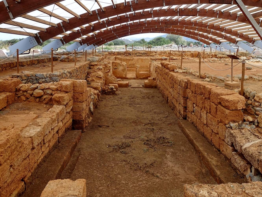
The Minoan royal villa at Ayia Triada, 3 km to the west of the palace of Phaistos, takes its name from the small medieval village in this area.
It is a superbly well-constructed building of considerable importance, and has yielded a wealth of outstanding finds. The history of Ayia Triada closely follows that of Phaistos, with which it was directly connected. The earliest traces of occupation in the surrounding area go back to the Neolithic period.
The archaeological evidence indicates that the site of Ayia Triada was continuously inhabited from the Pre-Palace period down to the 13th c. BC. Later, sanctuaries were built here in Protogeometric and Geometric periods, and the sanctuary of Zeus Velchanos functioned in the Hellenistic period; there are also sporadic finds from Roman and Venetian-Turkish times.
The archaeological site has three main centres: 1) the Minoan royal villa, dating from the New Palace period, and the Post-Palace buildings erected on its ruins, 2) the Minoan settlement and “agora”, and 3) the cemetery. The view has been advanced that the complex was a summer resort for the kings of Phaistos, and also that the rulers of Phaistos moved here after the decline of the palace.
The royal villa, or small palace, at Ayia Triada was erected in the New Palace period, about 1600 BC, and was destroyed at the end of the 15th c. BC, along with the palaces and the rest of the Minoan centers. It was decorated with palatial luxury, with gypsum facing slabs, painted floors, and wonderful wall-paintings. The villa has the shape of an irregular L. The ruler’s quarters are in the north-west corner of the complex, and comprise a main hall, with a portico and a light-well, a room with a “bench” and a revetment of gypsum slabs, and a peristyle courtyard with a fine view. The south-west part of the building has a series of rooms and is thought to have been the personnel quarters and there were other residential rooms, and storerooms in the north wing. Immediately to the south of the meticulous facade of the north wing is the Square of the Sanctuaries. The south-east side also has storerooms, cult rooms and residences. In the 14th c. BC the site was once more a powerful administrative center, as is clear from the fact that a new building programme was implemented, including the erection of two imposing structures – the larger of the two is in the type of the “Mycenaean” megaron – on top of the ruins of the north wing and the Square of the Sanctuaries. The Minoan settlement, the “village” of New Palace (17th-15th c. BC) and Post-Palace (14th-13th c. BC) periods, lies to the north of the villa. The “agora” was erected in the square on the east side of it, also in the 14th c. BC; this was a large complex of eight storerooms or shops, fronted by a long, rectangular portico with columns and pilasters. The cemetery, just to the north of the settlement, also contains two early tholos tombs. Some excellent finds have been yielded by the site at Ayia Triada: a wall-painting with cats, birds and lilies, a painted floor with dolphins and octopuses, three famous stone vases with relief scenes (Harvester Vase, Chieftain Cup, Boxer Rhyton), a large number of clay and bronze figurines, bronze ingots, inscribed tablets, jewellery, and lavish pottery. Special mention should be made of the unique stone sarcophagus, painted with composite scenes showing the cult of the dead.
All the finds are on display in the Herakleion Archaeological Museum.
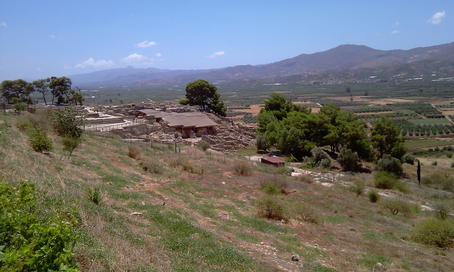
The palace of Phaistos (Faestos, Phaestos, Faistos) commands the Messara plain from its location on a low hill, and it is the second largest palace of Crete after The Palace of Knossos.
The site was inhabited since the late neolithic era with several well organized settlements on the hill and the surrounding area, and the first palace was built around 2000 BC. Excavations have unearthed a rich historical strata, and some ruins date back to neolithic times. The palace, just like the other palaces of Minoan Crete, was destroyed three times before it was rebuilt on the ruins of the old buildings in 1700 BC. Aesthetically, Phaistos is built on the most spectacular setting of all palaces in Crete, high on a dramatic hill, overlooking the entire Messara plain framed by the Asterousia mountain range which is sprinkled with small villages to the south, and the Lasithi mountains to the East. Looking to the West one encounters the Messara gulf just beyond the low hill of Agia Triada, and the dramatic 2456m tall solid body of Mt. Idi, otherwise known as Psiloritis towers above when one gazes north.
The architecture of Phaistos is more simplified compared with The Palace of Knossos, and it is built in an orderly arrangement that refers to a single architect. The building outlines and the ground plan is easily deciphered by the visitor at first glance, however further examination reveals the complexity built into the site over hundreds of years of destruction and rebuilding cycles. The complex of architectural elements is a delightful amalgam of the old and new palace structures. During the rebuilding of the palace in 1700 BC several of the rooms from the old palace were retained in the new building, and archaeologists today have excavated several areas of the new palace to reveal the older structures below. The pavement of the west courtyard along with the few bottom steps of the converging staircases have been exposed during modern excavations, for they were buried one meter deep when the new palace was built. The exposed levels of the old palace which have been retained by the Minoans or exposed by archaeologists paint a picture of architectural intricacy which rivals this of the new palaces. The old levels are best preserved at Phaistos, more than in other palaces around Crete, and have prompted scholars to conclude that the complexity of the structures was not dramatically increased during the rebuilding of the Neopalatial period. The raised processional walkway which traverses the western courtyard diagonally in the old palace connected this area to the main courtyard after an abrupt turn at the south end of the palace. Today this part of the walkway is covered under the buildings of the Neopalatial era.
The main courtyard is vast and it retains its original pavement of stones, and it offers unobstructed views of the Messara plain. The irrigation works under the central courtyard and the entire palace indicate an emphasis on sanitation which was a priority for all Minoan palaces. The palace of Phaistos used the small river Ieropotamos at the foot of the hill for its water supply, along with some deep wells on the palace itself. The builders of Phaistos took great care to create a functional as well as an aesthetically pleasing environment, which accommodated the spectacular views from the hill. The buildings are arranged around expansive courtyards following the uneven surface of the hill, and with their walls enclose the panorama of the Messara plain and Mount Idi to the south and North respectively. The spectators sitting at the theater would have had a great view of the south and the east. According to Vincent Scully, the buildings of the palace were constructed in such a way that the open areas were always enclosed on one side by a palace wall, and on the other side by a major mountain mass.
Phaistos was the home of Radamanthis, the brother of the legendary king of Minos. The palace continued to be used even after its destruction of 1400 BC, although it gradually lost its power until the emerging center of nearby Gortyn destroyed it finally in 200 BC.
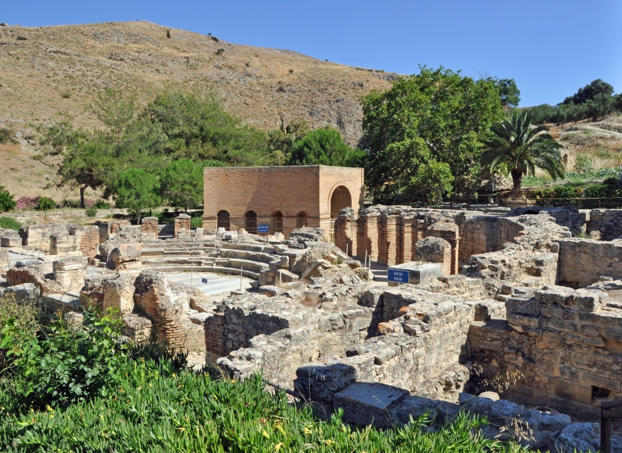
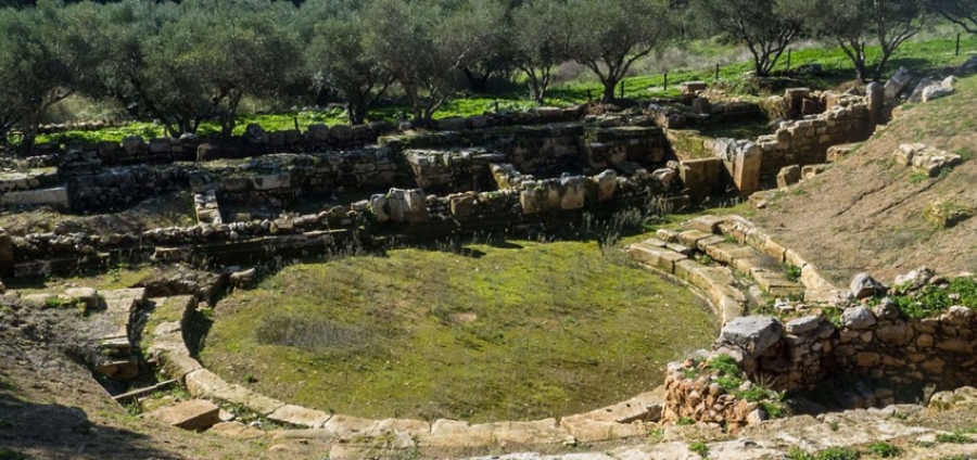
Gortyn, in the plain of Messara, was a major Cretan city, and one of the most powerful in historical times. Its architectural remains date mainly from the Roman and Byzantine periods and cover an area of about 2,000 square meters.
The excavations in the area were begun in 1884 by the archaeologist F. Halbherr and continue up to the present day. The habitation in the area of Gortyn from as early as the Neolithic period is attested by vases and stone tools found on the hills, to the north, and in the plain. The Minoan period is represented by the rich finds from the Neopalatial villa at Kannia.
In the Geometric period (11th-8th c. BC), a settlement evolved on the acropolis on the hill of Ai-Yannis, extending in the Archaic period (7th-6th c. BC) to the hill that was the site of the later Odeon, on which the earliest agora of the city was organized. A second agora later grew up in the area of the temple of Pythian Apollo. A fortification was built on the 7th century BC acropolis and a sanctuary was founded, from which the ruins of a temple survive, with some notable sculptures. A storage pit has also been uncovered containing clay finds dedicated to Athena Poliouchos. Of the Classical city (5th-4th c. BC), the remains are preserved of a building on the site of the Odeon, and inscriptions testifying to the influence exercised by Gortyn on other Cretan cities. It was here, in 470 BC, that the first silver Cretan coins were minted.
In the Hellenistic period (3rd-1st c. BC), the city brought the entire plain of Messara under its control and entered into friendly relations with the Macedonians and the Ptolemies. At the instigation of the latter, defense works were built on the hills to the north of Gortyn. Most of the building remains from this period are located in the village of Metropolis, buried beneath the ancient deposits of Roman and Byzantine times. In the Roman period (1st c. BC-4th c. AD), some imposing public buildings were erected in the area of the Praetorium, where a third agora developed, and at the same time the city was equipped with an extensive water-supply and drainage network.
St. Titus the apostle founded the first Christian church in Crete at Gortyn, and in AD 250 the Ten Saints (Ayioi Deka) were martyred here. Gortyn continued to flourish in the Early Christian and Early Byzantine periods (4th-9th c. AD), when there was extensive building activity, and the largest fortification wall on the acropolis was built in the reign of the emperor Heraclius (7th c. AD). Gortyn was destroyed by the Saracens in the early 9th c. AD, and has remained uninhabited ever since.
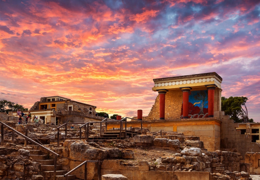
The Minoan palace is the main site of interest at Knossos, an important city in antiquity, which was inhabited continuously from the Neolithic period until the 5th c. AD. The palace was built on the Kephala hill and had easy access to the sea and the Cretan interior. According to tradition, it was the seat of the wise king Minos. The Palace of Knossos is connected with thrilling legends, such as the Mythology of Crete of the Labyrinth with the Minotaur, and the story of Daidalos and Ikaros.
The first excavation of the site was conducted in 1878 by Minos Kalokerinos of Herakleion. This was followed by the long-term excavations (1900-1913 and 1922-1930) of the Englishman Sir Arthur Evans, who uncovered virtually the entire palace.
The earliest traces of inhabitation in the area of the palace go back to the Neolithic period (7000-3000 BC). The site continued to be occupied in the Pre-palatial period (3000-1900 BC), at the end of which the area was levelled for the erection of a large palace. This first palace was destroyed, probably by an earthquake, about 1700 BC. A second, larger palace was built on the ruins of the old one. This was partially destroyed about 1450 BC, after which the Mycenaeans established themselves at Knossos. The palace was finally destroyed about 1350 BC by a major conflagration. The site it covered was occupied again from the Late Mycenaean period until Roman times.
Extensive reconstruction of the Palace of Knossos was carried out by the excavator, Sir Arthur Evans. It was a multi-storey building covering an area of 20,000 square metres. Impressive features of it are the variety of building materials used, and the painted plaster, marble revetment and wall-paintings adorning the rooms and passages. The advanced level of technology attained by the Minoans is also demonstrated by some original architectural and structural features, such as the light-wells and polythyra, the use of beams to reinforce the masonry, and the complex drainage and water-supply systems. The palace is set around a large Central Court, an area used for public meetings.
A second courtyard, the West Court, acted both as the official approach to the palace and a ceremonial area. The west wing was occupied by the official rooms for administrative and religious activities, including the Tripartite Shrine, the Sacred Repositories and the Pillar Crypts. The Throne Room is outstanding amongst them, with its lustral basin and the alabaster throne flanked by benches. The most important areas in the south wing are the South Propylon, the Corridor of the Procession and the South Entrance, with the fresco of the Prince of the Lilies. The east wing contained the residential quarters and large reception rooms, the most important being the Hall of the Double Axes and the Queen’s Hall. These rooms are approached by the imposing Grand Staircase. From the North Entrance, a road led to the harbour of Knossos. The North Entrance is flanked by elevated stoas, the one at the west being decorated with the Bull Hunt fresco. A large, stone-paved processional way, the Royal Road, led from the Small Palace and the city to the north-west corner of the palace, where there was an open-air theatral area.
Around the palace extended the Minoan settlement, with the cemeteries on the hills. Important buildings from this same period include: the South House, the House of the Chancel Screen, the Small Palace, the Caravanserai, the Royal Villa and the Temple-Tomb. The Villa Dionysos with its floor mosaics (2nd c. AD) is an important building of the Roman period.
The numerous finds from the palace, all of exceptionally high quality art, pottery, vessels, figurines, the archive of Linear B tablets, and the original wall-paintings, are all housed in Herakleion Museum.
We can assure you always Professional Private Services (365/24/7) with accurate program according to your preferences so that you can maximize your time and energy whilst on holiday or business
For more information, please contact us
|
FROM / TO
|
TO / FROM
|
Driving Destination
|
Driving Time
|
|
AIRPORT / PORT
|
HERAKLION CITY / PORT | 6 Km. | 12 minutes about |
| AIRPORT / PORT | AMMOUDARA | 14 Km. | 17 minutes about |
| AIRPORT / PORT | LINOPERAMATA | 16,5 Km. | 20 minutes about |
| AIRPORT / PORT | AGIA PELAGIA / LIGARIA | 26 Km. | 25 minutes about |
| AIRPORT / PORT | FODELE | 32 Km. | 28 minutes about |
| AIRPORT / PORT | BALI | 51 Km. | 45 minutes about |
| AIRPORT / PORT | PANORMO | 60 Km. | 55 minutes about |
| AIRPORT / PORT |
RETHYMNO (from Scaleta area to Creta Palace hotel) |
60 Km. | 60 minutes about |
| AIRPORT / PORT |
RETHYMNO (area after Creta Palace hotel and for the whole town and port) |
81 Km. | 1 hour and 10 minutes about |
| AIRPORT / PORT | GEORGIOUPOLIS | 104 Km. | 1 hour and 20 minutes about |
| AIRPORT / PORT | SOUDA | 125 Km. | 1 hour and 50 minutes about |
| AIRPORT / PORT | CHANIA | 137 Km. | 1 hour and 55 minutes about |
| AIRPORT / PORT | MALEME | 152 Km. | 2 hours and 5 minutes about |
| AIRPORT / PORT | KOKKINI HANI | 13 Km. | 14 minutes about |
| AIRPORT / PORT | GOUVES | 17,5 Km. | 16 minutes about |
| AIRPORT / PORT | HERSONISSOS | 24 Km. | 20 minutes about |
| AIRPORT / PORT | STALIDA | 30 Km. | 25 minutes about |
| AIRPORT / PORT | MALIA | 33 Km. | 30 minutes about |
| AIRPORT / PORT | SISSI | 40 Km. | 38 minutes about |
| AIRPORT / PORT | MILATOS | 47 Km. | 45 minutes about |
| AIRPORT / PORT | AGIOS NIKOLAOS | 60 Km. | 55 minutes about |
| AIRPORT / PORT | ELOUNDA | 71 Km. | 65 minutes about |
| AIRPORT / PORT | PLAKA (ELOUNDA) | 76 Km. | 70 minutes about |
| AIRPORT / PORT | ISTRON | 75 Km. | 70 minutes about |
| AIRPORT / PORT | IERAPETRA | 90 Km. | 1 hour and 10 minutes about |
| AIRPORT / PORT | FERMA | 102 Km. | 1 hour and 25 minutes about |
| AIRPORT / PORT | MAKRI GIALOS | 114 Km. | 1 hours and 40 minutes about |
| AIRPORT / PORT | SITIA | 130 Km. | 2 hours about |
| AIRPORT / PORT | AROLITHOS | 17 Km. | 25 minutes about |
| AIRPORT / PORT | ANOPOLIS | 16 Km. | 25 minutes about |
| AIRPORT / PORT | MATALA | 72 Km. | 1 hour and 5 minutes about |
| AIRPORT / PORT | AGIA GALINI | 79 Km. | 1 hours and 15 minutes about |
| AIRPORT / PORT | PLAKIAS | 114 Km. | 1 hour and 40 minutes about |
| AIRPORT / PORT | PALEOCHORA | 210 Km. | 3 hours and 10 minutes about |